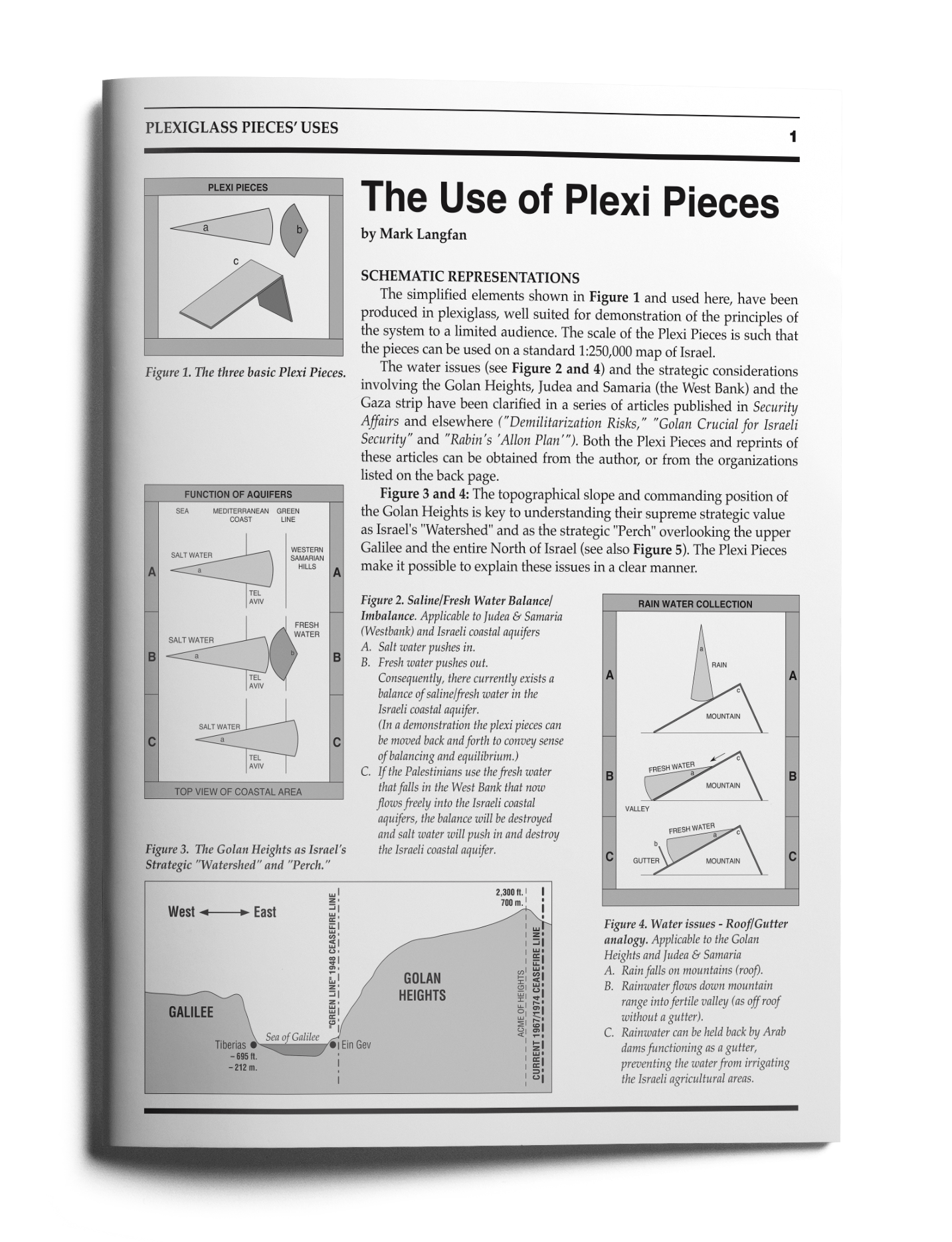


SCHEMATIC REPRESENTATIONS
The simplified elements shown in Figure 1 and used here, have been produced in plexiglass, well suited for demonstration of the principles of the system to a limited audience. The scale of the Plexi Pieces is such that the pieces can be used on a standard 1:250,000 map of Israel.
The water issues (see Figure 2 and 4) and the strategic considerations involving the Golan Heights, Judea and Samaria (the West Bank) and the Gaza strip have been clarified in a series of articles published in Security Affairs and elsewhere ("Demilitarization Risks," "Golan Crucial for Israeli Security" and "Rabin’s ‘Allon Plan.’"). Both the Plexi Pieces and reprints of these articles can be obtained from the author, or from the organizations listed on the back page.
Figure 3 and 4: The topographical slope and commanding position of the Golan Heights is key to understanding their supreme strategic value as Israel‘s "Watershed" and as the strategic "Perch" overlooking the upper Galilee and the entire North of Israel (see also Figure 5). The Plexi Pieces make it possible to explain these issues in a clear manner.
 [/et_social_share_media]
Figure 1. The three basic Plexi Pieces.
 [/et_social_share_media]
Figure 2. Saline/Fresh Water Balance/ Imbalance. Applicable to Judea & Samaria (Westbank) and Israeli coastal aquifers A. Salt water pushes in. B. Fresh water pushes out. Consequently, there currently exists a balance of saline/fresh water in the Israeli coastal aquifer. (In a demonstration the plexi pieces can be moved back and forth to convey sense of balancing and equilibrium.) C. If the Palestinians use the fresh water that falls in the West Bank that now flows freely into the Israeli coastal aquifers, the balance will be destroyed and salt water will push in and destroy the Israeli coastal aquifer.
 [/et_social_share_media]
Figure 3. The Golan Heights as Israel’s Strategic "Watershed" and "Perch."
 [/et_social_share_media]
Figure 4. Water issues - Roof/Gutter analogy. Applicable to the Golan Heights and Judea & Samaria A. Rain falls on mountains (roof). B. Rainwater flows down mountain range into fertile valley (as off roof without a gutter). C. Rain water can be held back by Arab dams functioning as a gutter, preventing the water from irrigating the Israeli agricultural areas.
The Golan mountains topographically channel attacking Syrian tanks through two key bottleneck areas (1) and (2) on the map in Figure 7 below. These natural terrain bottlenecks allow the defending Israeli general to maximize the defensive value of Israel’s small standing army by focusing his limited troops on only those two relatively small spots.
In the 1973 Yom Kippur War (as depicted on the map), the Golan’s strategic terrain enabled Israel’s standing force of 150 defending tanks to stop the Syrian standing force of 1500 attacking tanks. This "Breathing Space" gave the IDF the critical 48 hours to call up and deploy Israel’s reserve soldiers. For full explanations, please refer to the articles "Demilitarization Risks," "Golan Crucial for Israeli Security" and "Rabin’s ‘Allon Plan.’"
 [/et_social_share_media]
Figure 5. Radar - Line of Sight: Applicable to the Golan and Judea & Samaria A. Israeli Radar on crest enables Israel to see. B. Crest Blocks Arab Radar from Jordan out. C. If Israel moves back to green-line, Israeli Radar will be blocked. D. If Arabs control crest, they will have clear radar look into Israeli Air Bases and Mobilization points. E. Israeli AWACS (as a substitute for mountain based radar) operates far from front line (70 km) and therefore will be in international airspace and be vulnerable to easy destruction from ship-based anti-aircraft missiles in international waters.
 [/et_social_share_media]
Figure 6 (on right). Golan Heights - Balance of Standing Forces: Small Israeli Force holds back Large Syrian Force A. Israel control extends just over crest line in the current cease-fire line. B. The small Israeli force balances out the much larger Syrian force because it holds the crest. C. If Israel moves back just a little it loses crest and critical mountain passes and much larger standing Syrian Forces will overwhelm small standing Israeli Force.
 [/et_social_share_media]
Figure 7. The Golan as Israel‘s Strategic "Breathing Space."
 [/et_social_share_media]
Figure 8. Range of Katyusha Rocket and their Radar or Laser Designators The template hypothetical question uses 2 or 3 plexi pieces to demonstrate the large coverage effects of a few, possibly coordinated terrorist activities. What if: A. Katyusha is fired by a “terrorist” element? B. Illegal radar is turned on by a “terrorist” element? C. Illegal laser designator is turned on by a “terrorist” element? D. Illegal radar jammer is turned on by a “terrorist” element? E. Any combination of the above actions.
 [/et_social_share_media]
Figure 9. Range of Palestinian Katyushas (or laser designators or radars)
 [/et_social_share_media]
Figure 10. “Air space” and “air space control” by control of land and air. A. and B. 3 pie pieces facing East in Judea & Samaria equal: a) Israeli Radar b) Israeli Jets c) Israeli Air Defense Weapons. All of which will blunt air attack d*) from East. C. Without a), b) and c), but with 3 pie pieces facing West, represented by a*), b*) and c*): a*) Palestinian “Civilian” Radar. b*) Palestinian “Demilitarized” Helicopters. c*) Palestinian “light” Air Defense Weapons. “Light” = “Heavy” by Helicopter bay. D. As above, plus attacking aircraft d*), represented by the large pie slice d*) Palestinian Attack Aircraft - Knife - dagger. Israeli Air Bases of Ramat David and Lod
 [/et_social_share_media]
Figure 11. Airspace considerations: A. “Theoretical” Airspace Border. B. Mid-point extending Palestinian Air Defense Umbrella. C. “De facto” Palestinian Air Defense Umbrella, which will extend over and neutralize Lod and Ramat David as well as almost all of Israel’s strategic air bases. Such a de facto Palestinian Air Umbrella will paralyze Israel’s entire defensive capability.
 [/et_social_share_media]
Figure 12 (on right). Allon Plan Topographic Breakdown: a). Israel: Tel Aviv Coastal Plain b). Gradual downward slope of the Western two thirds of West Bank - Heavy Palestinian population c). Extremely steep slope of the Eastern one third of West Bank - Sparse Palestinian population except for Jericho d). Jordan - Allon Plan would keep area c), the part furthest from a) the Tel Aviv coastal plain. This area c) would be isolated and separated from the main Israeli population centers by Palestinian State in area b). It would also be surrounded by the Palestinian State b) and Jordan d).
 [/et_social_share_media]
Figure 13. Division of the West Bank under the 1970 Allon Plan.