It is widely assumed that Prime Minister Rabin’s pronouncement regarding “political” and “security” settlements are based on the Allon Plan. Yosef Goell, for instance, notes that “All indications are that Rabin is still largely guided by the general lines of the Allon Plan of the 1970’s, updated to the territorial, demographic and political developments of the 1990’s.” (“An end to hysterico-Messianic settlement,” August 28)
But a look at the Allon Plan shows that what Rabin is offering is something totally new. Not only is it at odds with the Likud’s position, it even violates basic elements of the Allon Plan itself.
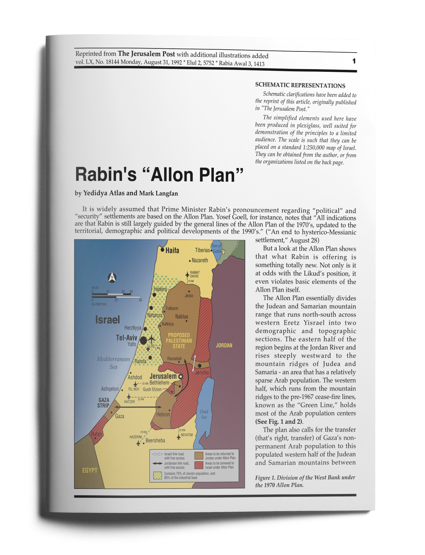
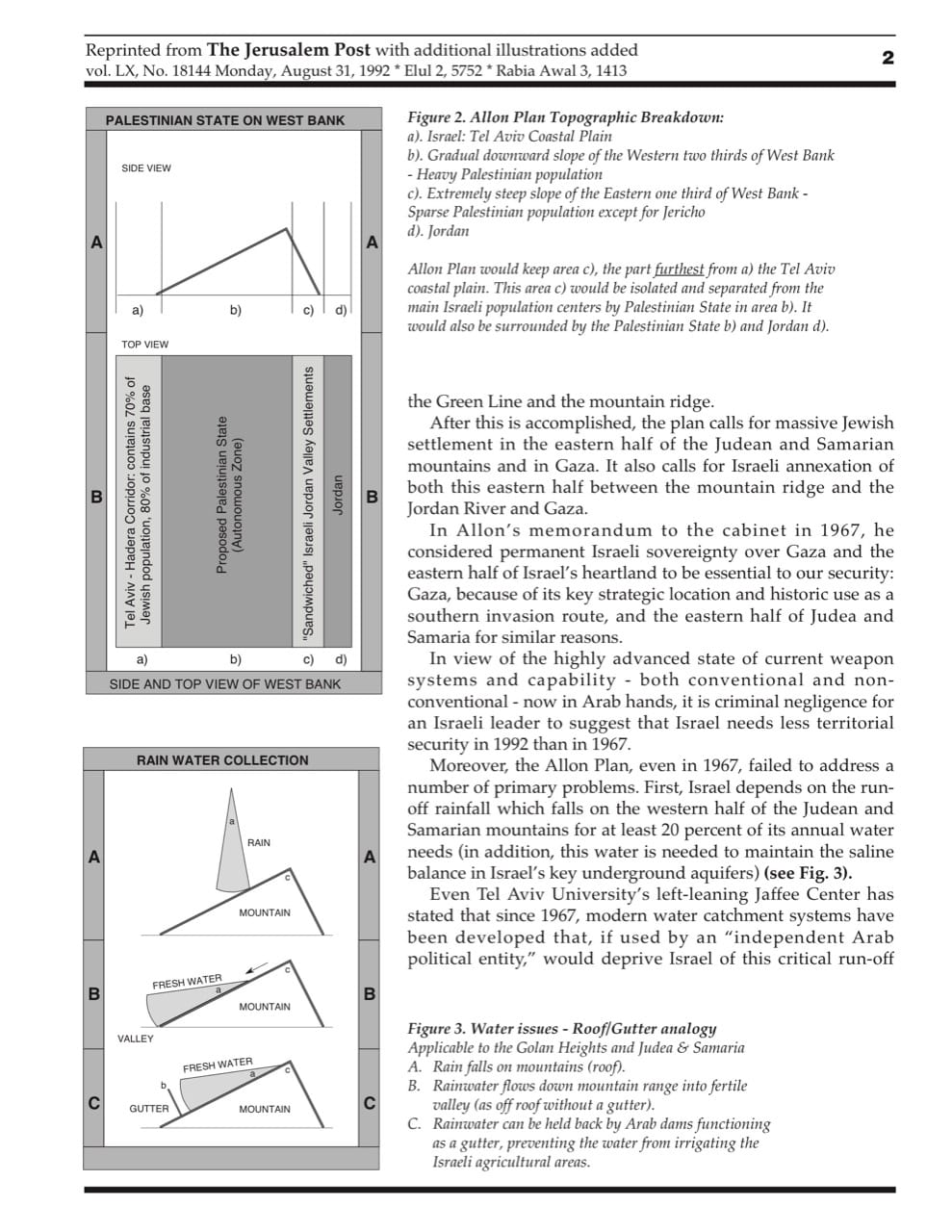
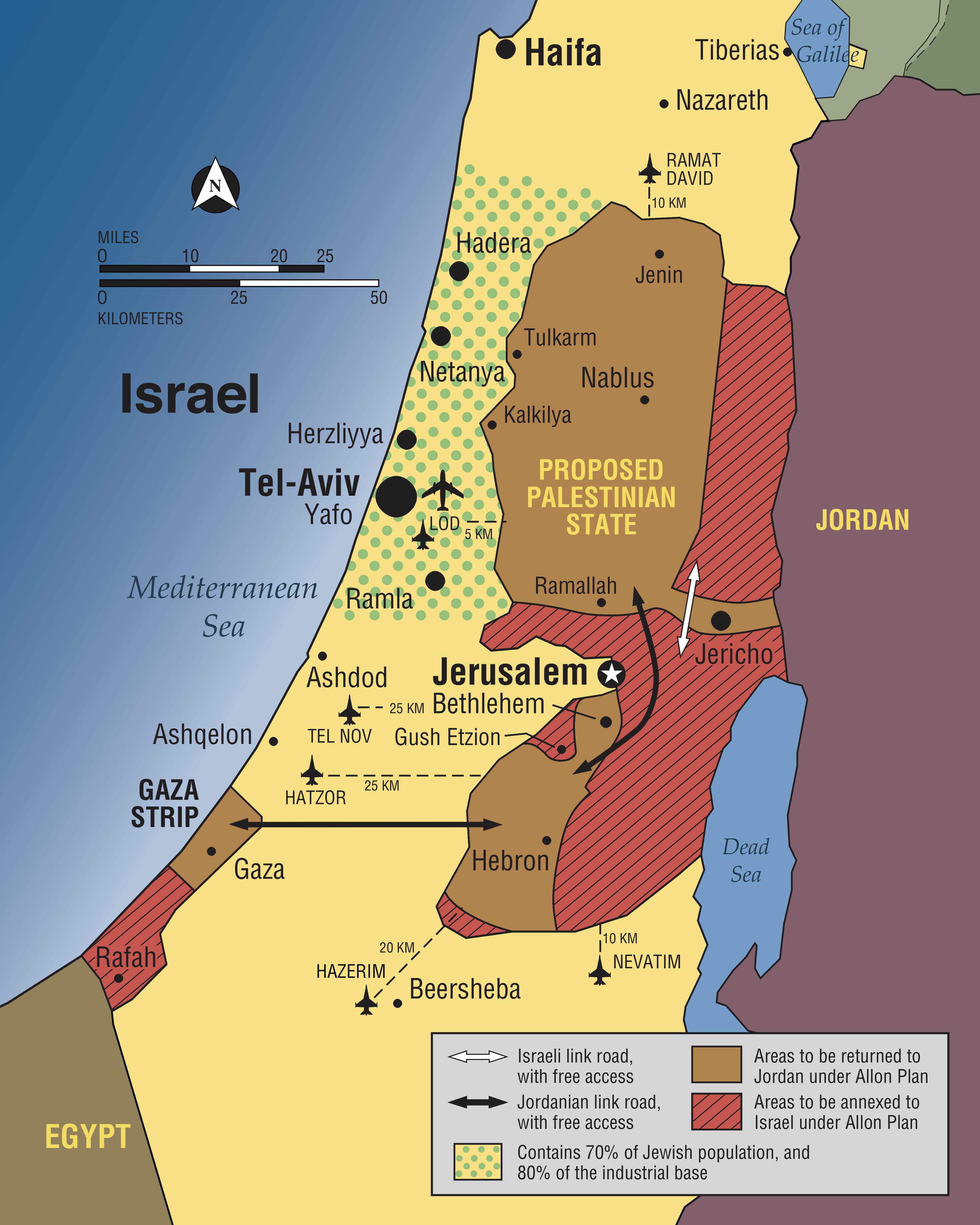
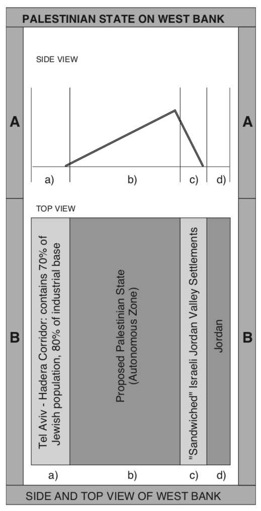
The Allon Plan essentially divides the Judean and Samarian mountain range that runs north-south across western Eretz Yisrael into two demographic and topographic sections. The eastern half of the region begins at the Jordan River and rises steeply westward to the mountain ridges of Judea and Samaria - an area that has a relatively sparse Arab population. The western half, which runs from the mountain ridges to the pre-1967 cease-fire lines, known as the “Green Line,” holds most of the Arab population centers (See Fig. 1 and 2).
 [/et_social_share_media]
Figure 1. Division of the West Bank under the 1970 Allon Plan.
 [/et_social_share_media]
Figure 2. Allon Plan Topographic Breakdown: a). Israel: Tel Aviv Coastal Plain b). Gradual downward slope of the Western two thirds of West Bank - Heavy Palestinian population c). Extremely steep slope of the Eastern one third of West Bank - Sparse Palestinian population except for Jericho d). Jordan Allon Plan would keep area c), the part furthest from a) the Tel Aviv coastal plain. This area c) would be isolated and separated from the main Israeli population centers by Palestinian State in area b). It would also be surrounded by the Palestinian State b) and Jordan d).
The plan also calls for the transfer (that’s right, transfer) of Gaza’s non-permanent Arab population to this populated western half of the Judean and Samarian mountains between the Green Line and the mountain ridge.
After this is accomplished, the plan calls for massive Jewish settlement in the eastern half of the Judean and Samarian mountains and in Gaza. It also calls for Israeli annexation of both this eastern half between the mountain ridge and the Jordan River and Gaza.
In Allon’s memorandum to the cabinet in 1967, he considered permanent Israeli sovereignty over Gaza and the eastern half of Israel’s heartland to be essential to our security: Gaza, because of its key strategic location and historic use as a southern invasion route, and the eastern half of Judea and Samaria for similar reasons.
In view of the highly advanced state of current weapon systems and capability - both conventional and non- conventional - now in Arab hands, it is criminal negligence for an Israeli leader to suggest that Israel needs less territorial security in 1992 than in 1967.
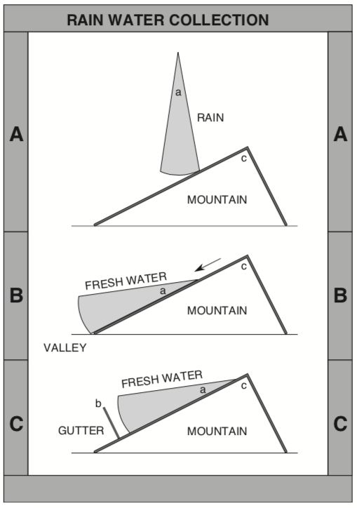
Moreover, the Allon Plan, even in 1967, failed to address a number of primary problems. First, Israel depends on the run- off rainfall which falls on the western half of the Judean and Samarian mountains for at least 20 percent of its annual water needs (in addition, this water is needed to maintain the saline balance in Israel’s key underground aquifers) (see Fig. 3).
 [/et_social_share_media]
Figure 3. Water issues - Roof/Gutter analogy Applicable to the Golan Heights and Judea & Samaria A. Rain falls on mountains (roof). B. Rainwater flows down mountain range into fertile valley (as off roof without a gutter). C. Rainwater can be held back by Arab dams functioning as a gutter, preventing the water from irrigating the Israeli agricultural areas.
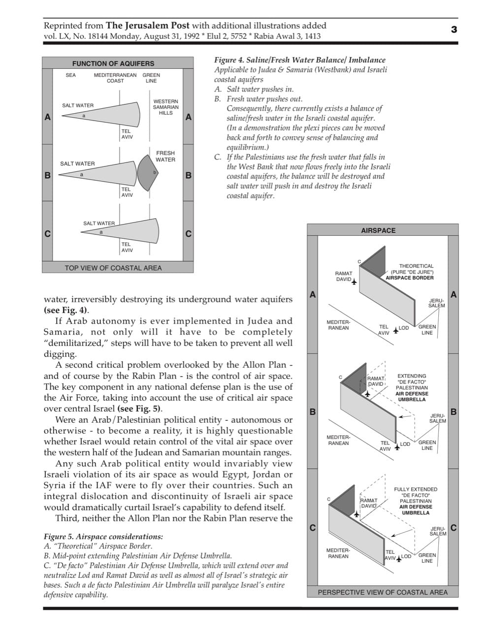
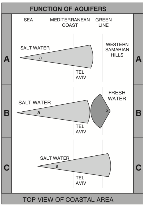
Even Tel Aviv University’s left-leaning Jaffee Center has stated that since 1967, modern water catchment systems have been developed that, if used by an “independent Arab political entity,” would deprive Israel of this critical run-off water, irreversibly destroying its underground water aquifers (see Fig. 4).
 [/et_social_share_media]
Figure 4. Saline/Fresh Water Balance/ Imbalance Applicable to Judea & Samaria (Westbank) and Israeli coastal aquifers A. Saltwaterpushesin. B. Fresh water pushes out. Consequently, there currently exists a balance of saline/fresh water in the Israeli coastal aquifer. (In a demonstration the plexi pieces can be moved back and forth to convey sense of balancing and equilibrium.) C. If the Palestinians use the fresh water that falls in the West Bank that now flows freely into the Israeli coastal aquifers, the balance will be destroyed and salt water will push in and destroy the Israeli coastal aquifer.
If Arab autonomy is ever implemented in Judea and Samaria, not only will it have to be completely “demilitarized,” steps will have to be taken to prevent all well digging.
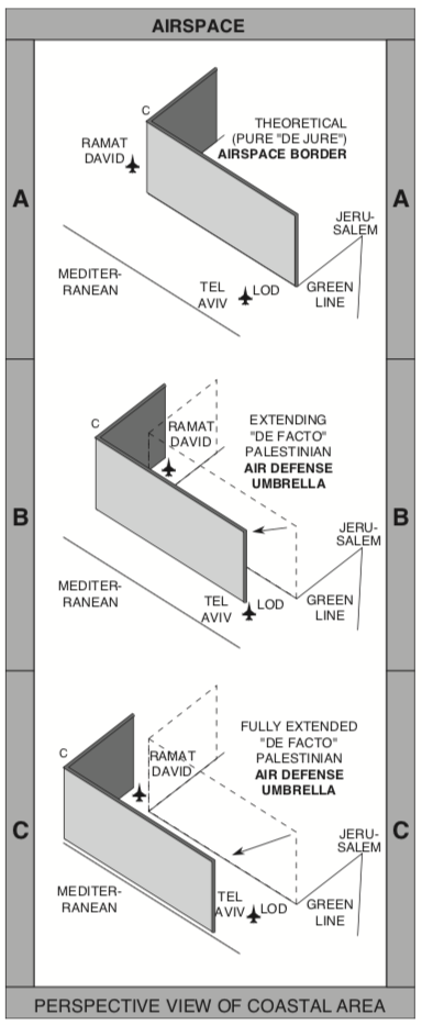
A second critical problem overlooked by the Allon Plan - and of course by the Rabin Plan - is the control of air space. The key component in any national defense plan is the use of the Air Force, taking into account the use of critical air space over central Israel (see Fig. 5).
 [/et_social_share_media]
Figure 5. Airspace considerations: A. “Theoretical” Airspace Border. B. Mid-point extending Palestinian Air Defense Umbrella. C. “De facto” Palestinian Air Defense Umbrella, which will extend over and neutralize Lod and Ramat David as well as almost all of Israel’s strategic air bases. Such a de facto Palestinian Air Umbrella will paralyze Israel’s entire defensive capability.
Were an Arab/Palestinian political entity - autonomous or otherwise - to become a reality, it is highly questionable whether Israel would retain control of the vital air space over the western half of the Judean and Samarian mountain ranges.
Any such Arab political entity would invariably view Israeli violation of its air space as would Egypt, Jordan or Syria if the IAF were to fly over their countries. Such an integral dislocation and discontinuity of Israeli air space would dramatically curtail Israel’s capability to defend itself.
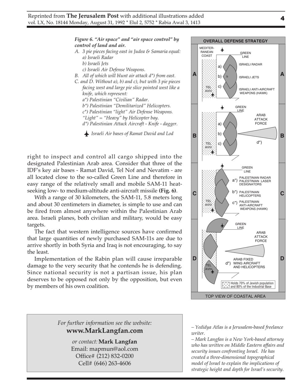
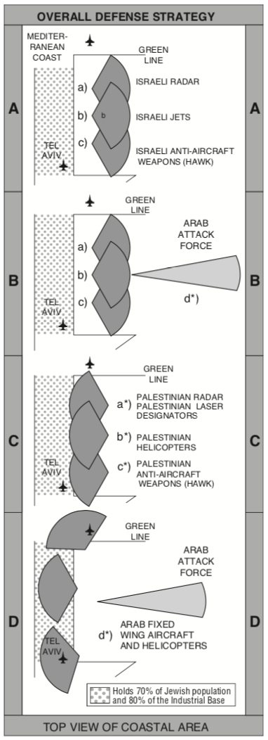
Third, neither the Allon Plan nor the Rabin Plan reserve the right to inspect and control all cargo shipped into the designated Palestinian Arab area. Consider that three of the IDF’s key air bases - Ramat David, Tel Nof and Nevatim - are all located close to the so-called Green Line and therefore in easy range of the relatively small and mobile SAM-11 heat- seeking low- to medium-altitude anti-aircraft missile (Fig. 6).
 [/et_social_share_media]
Figure 6. “Air space” and “air space control” by control of land and air. A. 3 pie pieces facing east in Judea & Samaria equal: a) Israeli Radar b) Israeli Jets c) Israeli Air Defense Weapons B. All of which will blunt air attack d*) from east. C. and D. Without a), b) and c), but with 3 pie pieces facing west and large pie slice pointed west like a knife, which represent: a*) Palestinian “Civilian” Radar. b*) Palestinian “Demilitarized” Helicopters. c*) Palestinian “light” Air Defense Weapons. “Light” = “Heavy” by Helicopter bay. d*) Palestinian Attack Aircraft - Knife - dagger. Israeli Air bases of Ramat David and Lod
With a range of 30 kilometers, the SAM-11, 5.8 meters long and about 30 centimeters in diameter, is simple to use and can be fired from almost anywhere within the Palestinian Arab area. Israeli planes, both civilian and military, would be easy targets.
The fact that western intelligence sources have confirmed that large quantities of newly purchased SAM-11s are due to arrive shortly in both Syria and Iraq is not encouraging, to say the least.
Implementation of the Rabin plan will cause irreparable damage to the very security that he contends he is defending. Since national security is not a partisan issue, his plan deserves to be opposed not only by the opposition, but even by members of his own coalition.
ABOUT THE AUTHORS:
- Yedidya Atlas is a Jerusalem-based freelance writer.
- Mark Langfan is a New York-based attorney who has written on Middle Eastern affairs and security issues confronting Israel. He has created a three-dimensional topographical model of Israel to explain the implications of strategic height and depth for Israel’s security.
NOTES:
Reprinted from The Jerusalem Post with additional illustrations added vol. LX, No. 18144 Monday, August 31, 1992 * Elul 2, 5752 * Rabia Awal 3, 1413
SCHEMATIC REPRESENTATION:
Schematic clarifications have been added to the reprint of this article, originally published in "The Jerusalem Post."
The simplified elements used here have been produced in plexiglass, well suited for demonstration of the principles to a limited audience. The scale is such that they can be placed on a standard 1:250,000 map of Israel. They can be obtained from the author, or from the organizations listed on the back page.

